

OKSANA


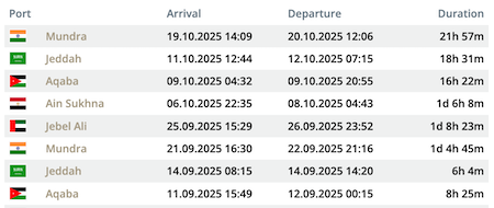
Die letzten Häfen
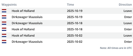
Die letzten Wegpunkte
Die neuesten Nachrichten
Entangled ships cleared from each other
Divers on Feb 26 made further inspections in order to ascertain the present position of the entangled anchor chain of the "Navaho" to the propeller of the "Oxana V". Subsequently, further operations were made by the diver's team, and the anchor chain was released from the propeller. The "Navaho" shifted to a convenience place and dropped anchor again in pos. 40° 57.63' N 028° 54.37' E. A detailed damage survey and inspection were under progress. The Turkish pollution control vessel "Erva" (MMSI: 271010393) moored at the "Navaho" for this purpose. Report with photos: http://www.denizcilikdergisi.com/denizcilik-gundem-haberleri/ahirkapida-kaza/
Cargo ships got entangled
On Feb 25, 2019, around 10 p.m. the cargo m/v "Navaho", while trying to anchor at Zeytinburu anchorage B near Istanbul in the Marmara Sea, got too close to the "Oxsana V", and the anchor chain got entangled with its propeller which suffered a crack. The lifeboat "Kıyı Emniyeti 3", which was later released by the "Kıyı Emniyeti 4", and the tugs "Kurtarma 7" and "Mehmetçik" were deployed by the General Directorate of Coastal Safety to assist. In the morning of Feb 26 the distance between the ships was 40 meters in pos. 40° 57.94' N 028° 54.23' E. The "Oxsana V" had sailed from Altinova at 5 p.m. and dropped anchor at 8.40 p.m. Turkish report with photos: http://www.denizhaber.com/kazalar/zeytinburnu-aciklari-b-demir-bolgesinde-gemiler-carpisti-h77485.html
News schreiben